The National Economic and Development Authority (NEDA) has underscored the need to harmonize and collaborate the application of remote-sensing technologies in the agricultural sector.
As the chair of the Inter-agency Committee on Inflation and Market Outlook (IAC-IMO), NEDA said it has been exploring the use of satellite-based technologies to manage inflation policies due to their potential in delivering data in a timely manner.
“The various remote-sensing technologies have significant potential to enhance our understanding, management, and policymaking for the agricultural sector,” said NEDA assistant secretary Reynaldo R. Cancio during a recent forum on satellite-based technologies in agriculture.
Cancio stressed that the IAC-IMO has been tasked with formulating and recommending policies to bring inflation back on target and manage it more effectively.
Recommendations from the inter-agency committee are elevated to the Economic Development Group (EDG) for further discussions and endorsement to the Office of the President.
During the forum, participants shared how they utilized satellite images, drones, artificial intelligence (AI), or a combination of these technologies, to generate agricultural data, such as crop planting areas expected crop yields, and flood risk areas.
Other remote-sensing technologies generate data on crop health and status, pest and disease incidence, and drought and flood hazard areas. Such information can be used in monitoring the supply situation and outlook on agriculture, said Cancio.
“There’s a lot that has already been done with these technologies, but there is still a lot that we need to do, especially when it comes to collaboration and coordination between the organizations present today,” Cancio added.
NEDA said it is optimistic that participants in the forum could come together again in the future to work towards harmonizing the technologies and expand its utilization to create timely and more reliable data sets for informing policy.
Moving forward, a series of forums with technology developers is envisioned to develop a harmonized and streamlined arsenal of remote-sensing technologies.
“We look forward to working together with all of you so that we can have a stronger and more advanced agricultural sector,” Cancio added.
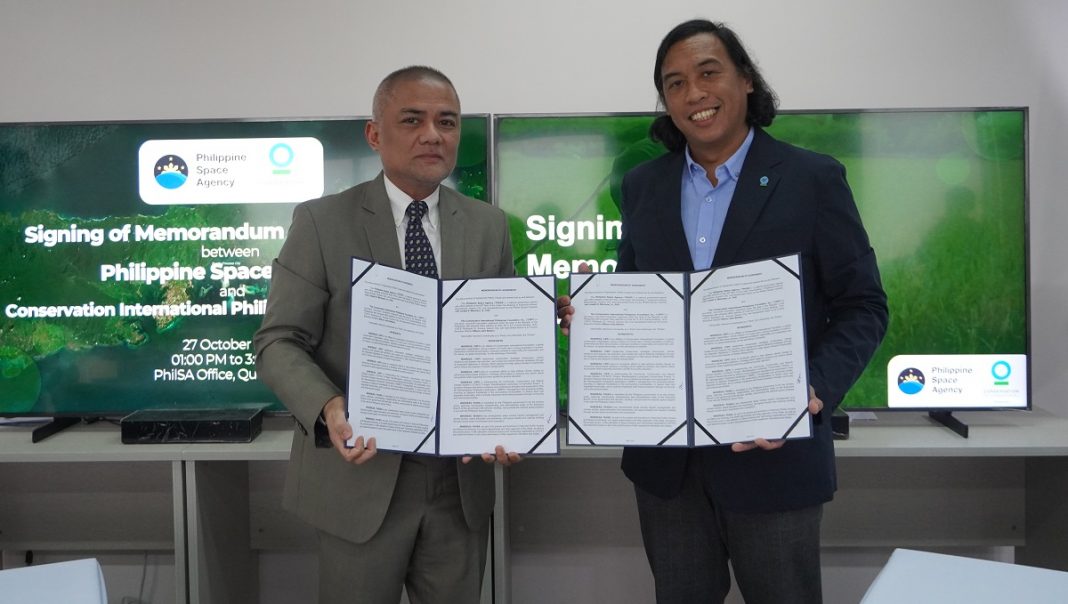
Meanwhile, the Philippine Space Agency (PhilSA) has inked an agreement with the Conservation International Philippines Foundation Inc. (CIPFI) to work on advancing environmental conservation and management through the application of remote sensing technologies.
The signing ceremony was held on Oct. 27 at the PhilSA office in Quezon City.
PhilSA director general Joel Joseph Marciano Jr. and CIPFI country executive director Wilson John Barbon formalized the cooperation through a memorandum of agreement (MOA) signing in Quezon City.
The agencies said the collaboration highlights a crucial step towards leveraging satellite and aerial remote sensing for environmental conservation.
“We are very interested in this collaboration with the PhilSA because it would allow us to explore technologies that are based on the work in space to develop efficient tools for ecosystem research, protection, sustainable management,” Barbon said.
“Some of these tools that we are currently using, and we are trying to develop even more include our own mapping, assessment, and estimation. If we can use space technology to look at mangrove and seagrass beds, that would really help in designing programs that are relevant in nature and people.”
The agreement covers the development of a strategic work plan to support CIPFI’s Community, Conservation, and Natural Climate Solution (CCNCS) Project: Mantalingahan Landscape Conservation Project in Southern Palawan, which aims to improve forest management of its protected landscape.
Other commitments include the conduct of learning and capacity building activities related to satellite data processing, programming, and usage of aerial mapping drones for forest monitoring and conservation; and sharing of expertise in aspects of sustainable development, environmental mapping, satellite remote sensing, and other space science and technology applications (SSTA); among others.
Aside from yearly reports that will be provided by the CIPFI to PhilSA, the former will also serve as one of the focal partners of the latter in implementing the PhilSA Integrated Network for Space-enabled Actions towards Sustainability (PINAS) project in Palawan and other project sites of the CIPFI.
PhilSA will provide technical assistance on the use of satellite and remote sensing data; cater to geospatial and mapping services; provide access to satellite data; and co-undertake research and development, and space data mobilization activities.


